Regional Highway Network: Difference between revisions
No edit summary |
No edit summary |
||
| Line 2: | Line 2: | ||
|title = Regional Highway Network | |title = Regional Highway Network | ||
|image = [[File:RHW Logo.jpg|thumb]] | |image = [[File:RHW Logo.jpg|thumb]] | ||
|caption = System Logo | |caption = System Logo | ||
|image2 = [[File:RHW MAP.jpg|thumb]] | |image2 = [[File:RHW MAP.jpg|thumb]] | ||
|caption2 = Network Map - Circa Feb 2012 | |caption2 = Network Map - Circa Feb 2012 | ||
|label1 = Builder | |label1 = Builder | ||
|data1 = [[wenchance]] | |data1 = [[wenchance]] | ||
Revision as of 03:46, 6 March 2020
 System Logo | |
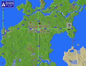
 Network Map - Circa Feb 2012 | |
| Builder | wenchance |
|---|---|
| World | New Wellstowne |
| Status | Finished |
| Constructed | March 2012 |
Regional Highway Network or RHWN is an integrated network of standardized wide thoroughfares that linked the communities of New Wellstowne and its periphery regions. The primary designer and constructor of the RHWN was wenchance.
Origins
Pre-Wellstowne
Before coming to the Pixelated Pickaxe server, wenchance had a presence on a couple of other servers where he had developed the standards for what would eventually become the RHWN standards. Some of the images of these roadway predecessors were used in Chance's application to the server.
Wellstowne Classic
The first instances of the RHWN on the Pixelated Pickaxe server came on Wellstowne Classic. The Regional Highway the linked Chance's home to Pixel Art Land and was the first of its kind. The single route used stone slabs and had blue wool signage demarcating its terminals.
Wellstowne Frontier
After initial developments on the Wellstowne Classic, the free-roam nature of the Wellstowne Frontier creative world led to the solidification of the design principles of the RHWN. A vast network of creatively-built RHW routes spread across the map with links to Dutchtown and various other developments.
New Wellstowne
As the Wellstowne Frontier world drew to a close, plans began to come together for a new world that would ultimately become New Wellstowne. New Wellstowne was to have a centralized development and a strong transportation network, this was when Chance was asked to take lead on the initiative. It was at this time that the RHWN would come into full being.
Construction
Initial Designs
Following the design choices made over the last two maps, the RHWN would adhere to a common standard. The RHWN would consist of two primary routes running in the cardinal directions from the spawn point and city center. Additional extensions and new routes would be added as development moved and expanded. The RHWN routes would also be accompanied by a minecart transit line of the Wellstowne Metro System.
Primary Development
Trunk route construction began immediately, alongside with city wall construction. The roadbed was to remain largely at grade level with sections that would be lofted and bridged if needed. Priority on roadway construction was given to the North-South and East-West routes while smaller local roads branched from the trunk.
Extensions
After the completion of the two main routes, extension construction began immediately as developments outside of the central city had already started to spring up. These extensions allowed for access to new locations like Pixel Art Land and the People's Technocratic Republic of Wensburrow. One prominent extension was RHW-4 which allowed roadway access to Aeronopolis via The Bridge of Camaraderie.
RHWN Standards
The RHWN follows a rigid and common standard that applies to all paths that are to hold the RHW name. The design standards of the RHWN would ultimately live past the New Wellstowne world and see its use in other worlds as well.
The standards are as follows:
- 7 blocks wide from curb to curb
- 2 lanes, one in each direction
- 1 block wide cobblestone slab centerline
- 2 block wide stone slab lanes.
- Cobblestone stairs must line each side as a curb
- Roadsigns are to use blue wool
- Signs are held up by wooden fence posts
Post New Wellstowne
The effort towards developing highway-based infrastructure was greatly decreased in maps following New Wellstowne.
Wellstowne Homestead
Roadways on the main continent, Wellstralia, were limited in scale. North-South running roads listed from west to east are Main Street (referred to as Interstate One beyond Wellstralia Borders), Wind Street, and Somethin' Boulevard. East-West roads listed from North to South are Desert Shitty Highway (DSH), Somethin' Boulevard, Market-Garden Street, Ely Street, Wind Street, Vanilla Bean Lane, and Main Street.
Main Street forms the only "highway" beyond the main continent and connects Wellstralia to Eastopia via an unnamed bridge. The Eastopia terminus of the bridge features signs referencing the "RHW" naming scheme, though this was not carried on beyond this point. It was also intended to connect Wellstralia to Manor Land. The highway is referred to as "Interstate One."
Wellstowne Reloaded
Burrowdizzy took the lead on developing the highway system spanning the city of Port Wellstowne and its periphery. While Burrowdizzy refers to the system as a spiritual successor the Regional Highway Networks developed by Chance Wen, he has developed a new system under theBURRCO moniker: The BURRCO Infrastructure Office for Maintenence and Enforcement (BIOME). Highways running East-West end in 5 and highways running North-South end in 0. Highway designations are two-letter, three-digit: the highways are HW-005, HW-010, and HW-015.
Highways building rules are as follows:
- 5 blocks wide
- 3 block wide stone slab with stone brick on either side
- Gentle slopes that follow the terrain
- Bridges and tunnels as deemed necessary by BIOME
- Street signs in city limits consist of three-block high fence topped with a torch and two signs
- Highways will be denoted with lime green wool beyond city limits
- Highway construction beyond Port Wellstowne region should remain limited to major developments
- Roads may exist to non-major developments. These should consist of pathway block or gravel
- These roads will not follow the HW-XXX naming scheme
- Denote roads as PR-XXX, with a three-digit number indicating the order of construction